|
Benchmarks: People &
Jobs
- Digital and Rare Map Librarian at Stanford University is named. Announcement from Julie Sweetkind-Singer: I have the pleasure to announce that G. Salim Mohammed has been named the new Digital and Rare Map Librarian at Stanford University. Salim has been hired as the head of the yet-to-be named Historic Map Center, which is slated to open in the next few years. This Center will house the David Rumsey Map Collection as well as rare maps from Special Collections and the Branner Library Map Collections. It will combine historical materials with state of the art technology, seamlessly blending a variety of cartographic and spatial materials to provide support for a wide variety of students, faculty and scholars in the pursuit of teaching and research. These efforts will go hand in hand with the map and geospatial collections and services available at Branner Earth Sciences Library & Map Collections.
Salim comes to us from the University of Hawaii at Manoa where he was the Maps/GIS Librarian. Salim arrived in Hawaii in early 2007, after the devastating October 2004 Halloween flood. One of his jobs was to spearhead the effort to move the paper map-based collection to a digital-heavy geospatial service model. He lead the efforts to digitize and georeference unique Hawaii maps as well as managed the creation of Manoa MAGIS (Maps, Aerials and GIS), first a virtual space to access digital content and later the build out of a lab space to support GIS use on the campus. Salim has a Master's in Geography and a Master's in Library and Information Studies, both from the University of Wisconsin-Madison.
New Maps of the WAML Region
Publications about Mapping
- A new list of articles from Phil Hoehn.
- Volumes One and Two of the classic History of Cartography series edited by J.B. Harley and David Woodward is now available online. Click on the link above; links to PDFs are available in the left column. One can search and download individual chapters and
search across all volumes.
- A Checklist of Dakin Publishing Company Fire Insurance Maps compiled by Phil Hoehn is now available. The original list, published in the WAML Information Bulletin 7:3 (1976) 50-51 contained 12 entries. This small revised list is doubled to 24. Additions are gratefully accepted.
- The "Jeopardy Guy", Ken Jennings, is coming out with a book about maps in September, entitled Maphead: Charting the Wide, Weird World of Geography Wonks. Here is an excerpt from US Airways Magazine.
Other Map Organization
Journals
- GSIS: Newsletter (posted 6 months after publication)
- NACIS: Cartographic Perspectives (note: In 2011, this will become a primarily digital, open access journal. Right now all issues are available online except the current issue).
- CUAC : Cartographic Users Advisory Council
- ANZMaps: The Australian and New Zealand Map Society Newsletter
|
News
WAML News
- WAML's spring meeting was held in Vancouver, BC, May 18-21. Tim Ross and Tom Brittnacher are to be congratulated on a great meeting filled with interesting sessions and, most unpredictably, beautiful weather. A note from Tom:
You can now view online several of the presentations that were given at the meeting. Click on the "Presentation" link following each listing to view a PDF version of the PowerPoint presentation. Here is a link to the Program page of the meeting website: http://waml.library.ubc.ca/program/
Nancy Meuth and Mia Costa's paper, GIS Trends in Libraries, will also appear in the July 2011 edition of the Information Bulletin. Sorry for the delay in getting this online. Please let me know if you have any problems accessing the files.
Also, here is a more detailed description from Ken Rockwell concerning the announcement of the recent geospatial project at the University of Utah library.
- WAML's next meeting will be Oakland on October 13-16. This will be a joint meeting with the Western History Association.
Registration is being handled by WHA and WAML members qualify at the WHA rate. Please see conference information below. Note: Pre-registration ends September 15th (save $10).
Here is the WAML Schedule for the meeting. We will have a separate sign up for the Stanford tour. The fee is to be determined but should be less than $20. Otherwise, we still have a few details to iron out but if you have any questions please contact me and I will try to answer them.
The WHA/WAML Conference Program Registration Form is available in PDF at:
http://www.westernhistoryassociation.org/wp-content/uploads/2011-WHA-Registration-Form-Online.pdf
You may also register online at the WHA General Store.
The entire Conference Program is online at:
http://issuu.com/westernhistoryassociation/docs/51st_wha_conference_program
I believe once you register WHA will mail you a paper copy of the program.
The Conference Hotel is the Oakland Marriott City Center. The link to the hotel may be found on the WHA website (on the "Conference" page). The hotel webpage is preset with the WHA's group code. Please see:
http://www.westernhistoryassociation.org/conference
and look under "Future Conferences." The conference rate is $149 a night. Below are three other hotel options close to the convention center, which should be cheaper. We are recommending that you stay close to the CC. I booked a room at the Washington Inn and it came out to $96 a night with taxes included. I was told parking here is $12 a night.
Clarion Hotel: http://www.clarionhotel.com/hotel-oakland-california-CAB03 - 371 13th Street, Oakland, CA 94612 (approx. $100-115)
Courtyard Marriott: http://www.marriott.com/hotels/travel/oakcd-courtyard-oakland-downtown/ - 988 Broadway, Oakland, California 94607 (approx. $129-169)
Washington Inn: http://www.thewashingtoninn.com/ - 495 10th Street, Oakland, CA 94607 (approx. $79-99)
- WAML member Dorothy McGarry participated in Capturing Our Stories: Developing a National Oral History Program of Retired/Retiring Librarians, an ALA Presidential Initiative project hosted at the University of Texas iSchool. Her interview is available here and through the above link.
Other News
- Historical Maps Released:
USGS Announces Initial Availability of Historical Topographic Quadrangle Maps of the United States (USGS news release). The U.S. Geological Survey (USGS) Historical Quadrangle Scanning Project (HQSP) is in the process of releasing all editions and all scales of more than 200,000 historic topographic maps of the United States dating from 1884-2006. For more than 130 years, the USGS topographic mapping program has accurately portrayed the complex geography of our Nation. The historical topographic map collection contains all editions and all scales of USGS topographic quadrangles. Files are high resolution (600 DPI) scanned images of all maps from the USGS legacy collection. The historical topographic map collection includes all States and U.S. territories mapped by the USGS. The HQSP creates a master catalogue and digital archive for all topographic maps and provides easy access to the public to download this historical data to accompany topographic maps that are no longer available for distribution as lithographic prints. Historical maps are available to the public at no cost in GeoPDF format from the USGS Store.These maps are georeferenced and can be used in conjunction with the new USGS digital topographic map, the US Topo. Future plans include providing the historical maps in GeoPDF andGeoTIFF formats through The National Map in the fall of 2011. The GeoTIFFs can be imported into a Geographic Information System and overlain with other data sources. More information about this product is available online. Additionally, a video of the HQSP presentation given at The National Map Users Conference (TNM UC) in May is now available online.
-
ALA/GODORT's Notable Government Documents for 2010/11 includes several map/geographic entires, including two websites from California.
- East View Cartographic recently acquired Map Link and relocated its operation from Santa Barbara, California to Minnetonka, Minnesota. A new website has been created at www.evmaplink.com. Here's the report from Publishers Weekly.
- Announcing Beta-1 Digital Version: Cahill-Keyes Multi-scale Megamap. This map comprising six major firsts, unprecedented in any other world map: 1) First-time-ever digital draft of an entire
single-frame world map at 1/1,000,000, with
2) a complete one-degree graticule, and
3) proportional geocells throughout, and
4) a three-fold grid spanning 40,000 km,
approximate Earth circumference, and
5) scalability from 1/1,000,000 down to 1/200,000,000 or beyond,
all with one-degree geocells, 6) a unitary world map whereby all complete or partial segments,
at any size, are scaled replicas of the same parent Megamap. And
two additional firsts for the Cahill-Keyes Megamap endeavor:
7) complete coastlines, and
8) complete international borders. Including for free download:
6 very large pdf's plus 13 others;
the entire one-piece 40 MB 1/1,000,000 Megamap file
(OOo: OpenOffice.org Draw);
the 2 programs which drew it,
enabling a "Do-it-yourself-Megamap".
- Map Analyst, The Map Historian's Tool for the Analysis of old Maps, is a (free) software for the accuracy analysis of old maps. Its main purpose is to compute distortion grids and other types of visualizations that illustrate the geometrical accuracy and distortion of old maps.
- Yale University buys early Kootenay map (Perry's Mining Map of the Southern Dist., West Kootenay, 1893). Described as one of the earliest obtainable printed maps to focus on the Kootenay mining regions, it will become part of Yale's Western Americana Collection.
- The London Map Fair was held in June. This preview by The Independent included several map images.
- The Dorothy Peyton Gray Transportation Library & Archives of the Los Angeles County Metropolitan Transportation Authority, with the cooperation of Occidental College, is digitizing the publication California Highways (1924-1967). This blog entry, Creating Pacific Coast Highway And Other Landmark Projects From 1924: Metro Library’s New Collection Of Historic California Highway Commission Documents, announces they have completed processing the first year of the publication.
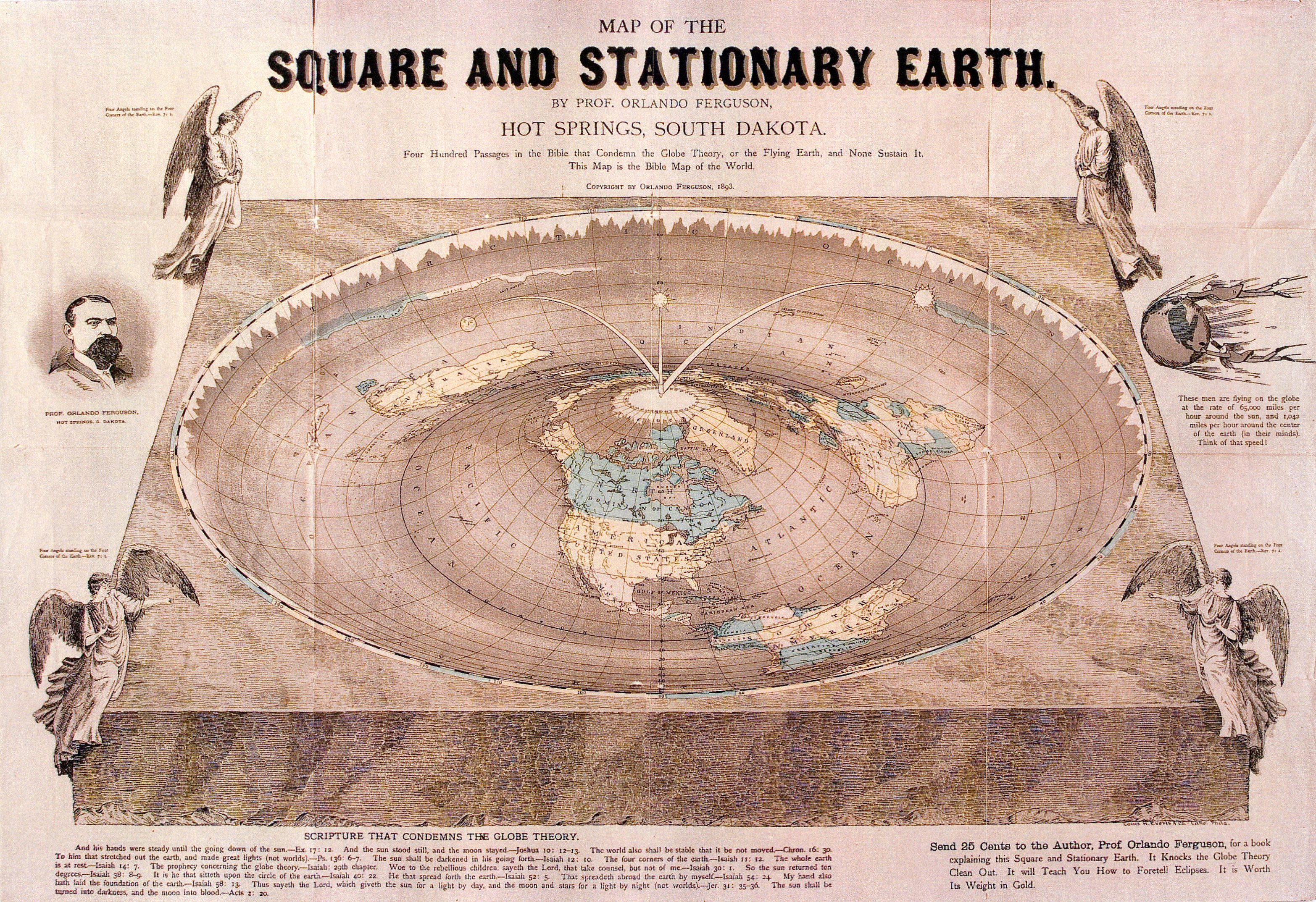
- Rare map of flat Earth is donated to Library of Congress (news story). The History Blog has some background as well as a hi-res version of the map. See also the Strange Maps post about the map. I especially like the note, Send 25 Cents to the Author, Prof. Orlando Ferguson, for a book explaining this Square and Stationary Earth. It Knocks the Globe Theory Clean Out. It will Teach You How to Foretell Eclipses. It is Worth Its Weight in Gold.
- The University of Utah is expanding its collection of online Sanborn maps: More digitized versions of 'irreplaceable' map collection available (Deseret News). The University of Utah's J. Willard Marriott Library recently announced a 77 percent increase to its collection of digital historical maps documenting the development of 26 Utah cities. The library's Sanborn Fire Insurance Co. collection now includes 1,950 maps. After copyright restrictions were lifted, the university was able to digitize maps through 1963, an additional 850 maps.
- The Map Room: A Weblog About Maps ceased on June 30th. The archives (dating to March 2003) will remain available.
- The United States Center of Population has moved again--now near Plato, Missouri.
- Epic intentions: With 63 cities down and 437 to go, artist Timothy Bruehl is painting the world, and nothing can stop him. (San Diego CityBeat) See also: http://www.artistincalifornia.com/ for more images.
- For the map fanatic who has everything: Cotton Percale Bedding with Antique Map design. Also, there are a variety of map products available through uncommongoods.
Future WAML Meetings:
Conferences, Classes & Exhibitions
- A report from the ALA Membership Blog on MAGERT's program, There's a Map for That, at the Annual Conference in New Orleans. The handout should become available on the Publications page. Incidentally, MAGERT (Map and Geography Round Table) has changed its name to MAGIRT (Map and Geospatial Information Round Table).
- Session presentation at the Coalition for Networked Information's spring meeting (April 4-5) by UCLA Professor Todd Presner: HyperCities: Using Social Media and GIS to Archive and Map Time Layers (YouTube video, 70 minutes).
- Reading Historical Maps Digitally: How Spatial Technologies Can Enable Close, Distant and Dynamic Interpretations (links to video, 41 min.) David Rumsey gave the opening keynote lecture for the Digital Humanities 2011 Conference at Stanford University on June 19, 2011.
Abstract of the talk: Maps are dense, complex information systems arranged spatially. While they share similarities with other visual artifacts, their uniqueness as spatially arranged visual information both allows for and demands special digital approaches to understand and reuse their content. Georeferencing, vectorization, virtual reality, image databases, and GIS-related tools all work to unite our eyes, minds, and computers in new ways that can make historical maps more valuable and accessible to humanists concerned with place and space over time. Rumsey will explore the tools and techniques that have implications for the ways digital humanists approach visual information. Read more about the talk.
- Just in time for our meeting in Oakland is this exhibition:
July 1, 2011 - October 31, 2011 - San Francisco
Mapping The Pacific Coast, at the San Francisco Maritime Museum, 900 Beach Street, showcases rare, historic maps, books and illustrations of Pacific Coast exploration, dated 1544 through 1802. These historic stories are told through original maps of the time and illustrations – the earliest being woodcuts and the majority being copperplate engravings, many in original hand color. Mapping the Pacific Coast was originally shown at the Sonoma County museum in 2004, and has been on tour around the country ever since. Other venues have included the Mystic Seaport Museum, in Mystic, CT. and the Maritime Museum of San Diego. Following its exhibition in San Francisco, the exhibit will move to its permanent home in Oregon, at the Columbia River Maritime Museum. (via Cartography - Calendar of Exhibitions)
Back to top
Cataloging News
Canadian News
Back to top
New
Maps & Web Sites of Interest
- Mapnificent is Google map mashup which shows you areas you can reach with public transport in a given time. See also: Find everywhere you can go in 15 minutes or less (FlowingData).
- Linguistic Geographies: The Gough Map of Great Britain is a new site exploring one of the earliest maps to show Britain in a geographically-recognizable form.
- East View Cartographic has created a mosaic of the map sheets over Sendai, Japan and the other tsunami affected areas and built a web-mapping service (WMS) to host the data for viewing around the world.
The WMS of these mosaiced rasters can be viewed in several ways:
- For use in your internet browser: EVC Web Application
- For use within your GIS software: Web Mapping Service (WMS)
- For use within your web applications or ArcGIS Online: REST Endpoint
- Recent additions at DavidRumsey.com (June 18): 1,676 new maps and images have been added to the David Rumsey Map Collection, bringing the online collection to 27,800 maps and images. Included in this addition are 666 images of Pocket Maps, a rare edition of Sanborn's 1905 Atlas of San Francisco from the S.F. Public Library which shows the city just before the earthquake and fire of 1906 - the atlas pages show burns from the fire. Also the 1889 Cram Standard American Atlas and the 1901 Cram American Railway Atlas. 325 more images from the Karte des Deutschen Reiches are added and the large composite image is increased to 501 maps (the next update will finish it at 674 maps). All titles may be found by clicking on the View links or images below. Or click here to view all 1,676 new maps and images.
Also recently added:
The first Atlas of Russia from 1745 has been added to the online collection. It was published by the Academy of Sciences in St. Petersburg, Russia, expanding on the cartographic work done previously by Russian cartographer Ivan K. Kirilov. Joseph Nicolas de L'Isle, the great French astronomer, was invited by the Academy of Sciences in 1726 to come to St. Petersburg to oversee the production of the atlas, although his role and contributions to the atlas are disputed by historians. The atlas maps present the first complete national survey of the entire country at uniform scales for European and Asiatic Russia. Alexei Postnikov, author of "Russia in Maps," says this atlas "brings together all the geographical discoveries of the early 18th century to give a fuller picture of the entire Empire than shown in the so-called Kirilov atlas. The maps were mostly based on instrumental surveys, geographical descriptions and maps compiled by the Petrine geologists and their successors." Normally the atlas includes 20 maps; this copy is special in adding an additional 17 maps and 2 text pages, including plans of St. Petersburg and Moscow (similar to a copies at the Library of Congress, Phillips 4060 and Phillips 3109). The maps have titles in German and Latin; place names are in Russian and Latin alphabet. The text of cartouches is in Latin. The atlas was also issued with French and Russian title pages and text, with the title Atlas Russicus and Atlas Rossiiskoi. This copy contains 7 pages of text with descriptions of the maps and explanations of geographical names and symbols used in German, Russian, French and Latin, a general map of the Russian empire, 13 maps of European Russia at a uniform scale of 1:1,470,000 (35 versts to one inch, 1 verst equals 3,500 feet), and 6 maps of Siberia at a uniform scale of 1:3,444,000 (82 versts to one inch). Bound in at end of the atlas are 19 additional text and maps of Russian territories, plans from the Russo-Turkish war of 1736, engravings of military fortifications, maps of Ladoga Lake, environs of St. Petersburg, Kronstadt and the Gulf of Finland. Maps are colored in outline, with some maps in full color. We have added 2 composite images of all 13 maps of European Russia and all 6 maps of Siberia. The atlas was printed in September 1745 in St. Petersburg. View the atlas.
- A collection of fantasy maps online (click on the red map link; most will expand by clicking on the map). See also: Art of the Genre: Maps and World-Building.
- The World Map of Useless Stereotypes (NY Times Magazine)
|
