|
Benchmarks: People &
Jobs
- Recent retirements: Cynthia Moriconi from the Univeristy of California, Santa Cruz; Carol La Russa from the University of California, Davis; Riley Moffat from BYU-Hawaii. Congratulations and all the best, Cynthia, Carol and Riley!
-
A note from Mabel Suzuki: Riley Moffat retired from BYU-Hawaii at the end of June. He thought he sent an announcement to WAML-L, but apparently it did not make it in. So I am copying his message below. Needless to say, we really miss having Riley Moffat on the island. He was instrumental in getting us to participate in WAML and has always been a very good friend to us and to our collection. We have inherited quite a bit of his map collection when they started downsizing. It was great blessing for us after the 2004 Flood. He has promised to be back in Hawaii from time to time since he has family here as well as in Utah. (He still retains his BYUH email for now: riley.moffat@byuh.edu)
Mabel K. Suzuki
Government and Maps Dept.
University of Hawaii at Manoa Library
Aloha all,
Just a quick note to all my fellow WAML-ites to let you know that I retired on June 30th and have moved from Hawaii (ouch!) to Orem, Utah (cheaper). I have tremendously enjoyed my association with WAML over the past 36 years and the friendships and professional support of the organization. As we surfers say "it's been a great ride" and hopefully there'll be more waves to come.
Riley Moffat, formerly of BYU-Hawaii
New Maps of the WAML Region
Publications about Mapping
- An article of of interest from Phil Hoehn:
Hart, John. 2014. Map Sense: from Topos to Tables at the East Bay Regional Park District. Bay Nature, v. 14, no. 1 (Jan-Mar): 18-23.
It opens with this nice paragraph:
"The average map, I've always felt, is more interesting than the average book. It can certainly tell you more about a place, faster. A map shows relationships; it raises questions; it hints at narratives."
- Civil War mapping: A Mysterious Map of Louisiana by Susan Schulten opines: ...the idea of mapping data in the United States can actually be traced to the Civil War. Earlier posts in Disunion have discussed the maps of slavery generated by the United States Coast Survey. At the same time, the Census Office (also part of the Treasury Department) was experimenting with maps of not just one but multiple types of data. These were designed to aid the Union war effort, but perhaps more importantly to plan for Reconstruction... (New York Times)
- Mapping and World War I:
* How World War I Launched Mapmaking at National Geographic: ...it was National Geographic's maps that quickly helped Americans grasp the sweep of a conflict so vast that it would later become known as the First World War....National Geographic revamped its August 1914 issue to include a map of "New Balkan States and Central Europe," which featured the names of the places where fighting was most severe. The maps were popular, boosting the organization's visibility. By year's end, membership in the Society had grown 50 percent, to more than 336,000.... Although National Geographic is well known today for its maps and atlases, the magazine did not actually create its own maps during the first 27 years of its existence.
(National Geographic)
* In the Trenches: British surveyors made a crucial contribution during World War I—an accurate map of the battlefield
(Fine Books & Collectibles Magazine)
- Roger Tomlinson and The Unlikely History of the Origins of Modern Maps: GIS technology has opened up new channels of understanding how the world works. But where did it begin? (Smithsonian)
- Some really nice cartography here: The Cartographer Who Mapped Out Gotham City: Batman has been guarding Gotham for 75 years, but its city limits weren't defined until 1998. (Smthsonian)
- Two books featured by Maria Popova of brain pickings:
* Cartographies of Time: A Visual History of the Timeline: A chronology of one of our most inescapable metaphors, or what Macbeth has to do with Galileo. I was recently asked to select my all-time favorite books ... the selection included Cartographies of Time: A History of the Timeline by Daniel Rosenbergand Anthony Grafton — among both my 7 favorite books on maps and my 7 favorite books on time, this lavish collection of illustrated timelines traces the history of graphic representations of time in Europe and the United States from 1450 to the present, featuring everything from medieval manuscripts to websites to a chronological board game developed by Mark Twain....
* Legendary Lands: Umberto Eco on the Greatest Maps of Imaginary Places and Why They Appeal to Us “Often the object of a desire, when desire is transformed into hope, becomes more real than reality itself.” Celebrated Italian novelist, philosopher, essayist, literary critic, and list-lover Umberto Eco has had a long fascination with the symbolic and the metaphorical, extending all the way back to his vintage semiotic children’s books. Half a century later, he revisits the mesmerism of the metaphorical and the symbolic in The Book of Legendary Lands(public library) — an illustrated voyage into history’s greatest imaginary places, with all their fanciful inhabitants and odd customs, on scales as large as the mythic continent Atlantis and as small as the fictional location of Sherlock Holmes’s apartment....
The Book of Legendary Lands is magnificent in its entirety. Complement it with Codex Seraphinianus, history’s most beautiful encyclopedia of imaginary things, and Where You Are, a wonderful case study in cartography as wayfinding for the soul.
- New book: The True Geography of Our Country Jefferson's Cartographic Vision by Joel Kovarsky
Other Map Organization
Journals
- GSIS: Newsletter (posted 6 months after publication)
- CUAC : Cartographic Users Advisory Council
- ANZMaps: The Australian and New Zealand Map Society Newsletter
|
News
WAML News
- The next WAML will be held at the UCLA campus in Los Angeles from September 3-6. An invitation from the WAML President:
Colleagues:
I'd like to announce that registration is open for this fall's Western Association of Map Libraries meeting.
We will gather on the campus of UCLA from September 3 through 6. The conference is an affordable $85, which includes lunch on Thursday and Friday. We have scheduled a full program of 9 presentations--that's 4 times the mappy content of an ALA meeting, at a third of the price! Plus: far fewer committee meetings ;)
Our talks feature everything from a new collection of 20th century maps and atlases at the LA Public Library to an introduction to linked spatial data for the semantic web.
Our Saturday field trip is currently being organized, but we know it will include a docent led tour of the Hammer Museum on the UCLA campus, and it's gonna be FREE!! Very affordable housing is available on campus, a short walk away from our meeting venue.
If you have never attended a WAML meeting before, please do consider joining us in Los Angeles. It's going to be a great meeting. Details and registration at:
http://www.library.ucsb.edu/map-imagery-lab/waml-ucla
__________
As I am writing my first presidential update for the Information Bulletin I just wanted to stop and send a quick e-mail to you all reminding you that our membership runs on a July to June calendar, which means that it is membership renewal time.
Renewing your membership is easier than ever: simply go to
http://waml.org/mbrinfo.html
and click the 'Pay Now' button. At this page, you will also see a form that you can print and mail to Kathy Stroud up in Eugene. (You can also renew when registering for the conference.--ed.)
And don't forget our upcoming conference at UCLA! The meeting is coming together very nicely with the indispensable help of Louise Ratliff, Map Catalog Librarian and our local host at UCLA. Hopefully by the time we meet in September, I will be able to announce a 2015 meeting venue.
See you in Hollywood!
Jon Jablonski, co-host: WAML-UCLA
Map & Imagery Laboratory
UC Santa Barbara
- I am pleased to announce that our 2014/2015 candidates received unanimous support from the membership.
68 members voted and there were no abstentions.
The new officers are:
Chris Thiry, Vice President/President Elect
Chrissy Klenke, Secretary
Congratulations to Chris and Chrissy!
--
Janet E. Dombrowski
WAML Secretary 2013/2014
- Chris Thiry's webinar from May 7th on How to Create Map Indexes Using GIS can be found here: http://library.mines.edu/LIB-Maps-GIS-Instructions
Other News
-
Green Library to house David Rumsey Map Collection: This summer, Stanford has started preparations to receive the David Rumsey Map Collection -- considered one of the world's largest collections of rare and antiquarian maps. The collection will arrive in the next year or two and will be housed in the soon-to-be-built David Rumsey Map Center in Green Library.
-
Scanning a gigantic map at Stanford's Oversized Imaging Lab: How Big is a Big Map? Digitizing William Smith's Stratified Map of England, Scotland and Wales from 1815
- The GIS in the Digital Humanities conference was recently held in Switzerland. Information and videos from the conference can be viewed here: http://dh2014.org/
- ISHMap-List: new Map History email listserv:
Back in the old days, questions or announcements related to any aspect of cartographic history were easily broadcast far and wide via the MapHist listserv. A few years ago, MapHist migrated away from an email listserv to an on line forum. Although well designed, the forum has failed to maintain the passion and level of discussion that existed previously in MapHist’s listserv format. In an effort to recapture those qualities, the International Society for the History of the Map recently created the ISHMap-List, an email listserv open to anyone interested in cartographic history. You can sign up for this email discussion group at no charge via this web site: http://lazarus.elte.hu/cgi-bin/mailman/listinfo/ishm.
Although membership in ISHM is not required to subscribe to ISHMap-List, you are welcome to join ISHM here.
Update: An announcement was made on 19 June 2014 that the MapHist Forum will be closed and web site removed by January 2015. That’s all the more reason to sign up for the ISHMap-List. (William P. Cumming Map Society, North Carolina)
- Two reports from Julie Sweetkind-Singer about the National Geospatial Advisory Committee:
As you may have read, I have been appointed to the National Geospatial Advisory Committee (NGAC) serving a three year term. We meet four times a year - three times in person and once via Webinar. I will be disseminating reports after each meeting. Please contact me with any questions you have and I'll be happy to answer them. I may ask for opinions/help as I sit on the committee as we deal with issues of importance around geospatial data.
Background
The NGAC is a Federal Advisory Committee sponsored by the Department of the Interior. We report to the Chair of the Federal Geographic Data Committee (FGDC). Here is our Charter: “The Committee will provide advice and recommendations related to management of Federal and national geospatial programs, the development of the National Spatial Data Infrastructure, and the implementation of Office of Management and Budget Circular A-16 and Executive Order 12906. The Committee will review and comment upon geospatial policy and management issues and will provide a forum to convey views representative of non-federal stakeholders in the geospatial community.” Here is the Website for the NGAC: http://www.fgdc.gov/ngac.
The NGAC has 30 committee members and of that number, 17 of us were new as of this year. We represent the government (local, state, regional, tribal, national), industries, legal, and academia. You can see a list of the members here: http://www.fgdc.gov/ngac/membership.
Meeting: April 1-2, 2014
All of the notes from the meeting are available online here: http://www.fgdc.gov/ngac/meetings/april-2014/index_html.
We met over the course of the two days where we got to meet with the FCDC Chair, Anne Castle and the FGDC Executive Committee. These are the folks that set the agenda about what we'll work on in our committees over the course of 2014. The FGDC has a number of ongoing initiatives for which NGAC provides guidance. These include the geospatial platform, the NSDI Strategic Plan and the National Geospatial Data Asset Management Plan (A-16 Plan).
One of the goals of the meeting was to get the sub-committees staffed with the new members. There are four sub-committees:
1. Landsat Advisory Group (LAG). (I am now a member of this group.)
2. Geolocation Privacy
3. Geospatial Education and Workforce Development
4. National Address Database
Here's a bit more information about each sub-committee as to their focus in 2014.
1. Landsat Advisory Group: Review and update the 2012 LAG paper, “The Value Proposition for Ten Landsat Applications,” refining the list of user applications and enhancing the Landsat value summary. Since the 2012 paper was completed, USGS has gathered additional information through a Landsat user survey, Landsat-user case studies, and a pilot project on remote sensing user requirements.
2. Geolocation Privacy: Inventory communities/sectors with an interest in geolocation privacy issues (e.g., State and local government organizations) to identify emerging approaches and potential best practices to help address geolocation privacy concerns, including: administrative policies and guidelines, technical approaches and solutions, legislative/statutory changes.
3. Geospatial Education: Identify opportunities to leverage recent professional GIS certification initiatives by the GIS Certification Institute (GISCI) and the National Geospatial-Intelligence Agency. Provide input as needed on the implementation of the Administration’s STEM strategic plan (government-wide, or within specific agencies, as appropriate).
4. National Address Database: Identify compelling use cases demonstrating the value and utility of a National Address Database. Describe the potential relationship between a National Address Database and National Parcel Data and identify possible opportunities to coordinate and leverage the two efforts.
Three emerging topics were identified and members were assigned to study these further and report back to the group when we meet in June.
1. NSDI sustainability and continuity
2. Tribal geospatial issues
3. Administration/departmental priorities
We had a series of lightning talks, which are all linked from the meeting page if you're interested. The work between now and our next meeting will all take place in the sub-committees.
Our next meeting will take place at the Department of the Interior June 24-25th. These meetings are open to the public and I encourage you to attend if you are in the DC area. They are interesting and engaging. The tentative agenda will be to have sub-committee status reports, a presentation on FirstNet, and the NGAC liaisons will report on the Emerging Topics discussions.
__________
The National Geospatial Advisory Committee (NGAC) met on June 24-25th. Here are the highlights of the meeting. This is long, but packed with interesting things, I can assure you!
1. The agenda and meeting information has been posted here: https://www.fgdc.gov/ngac/meetings/june-2014/index_html
2. Anne Castle (Assistant Secretary for Water and Science)
* She noted that this is a critical time for the Landsat program. A team is working on the vision and architecture for Landsat 9. Right now Landsat 7 and 8 are both up and running giving an image of each spot of the earth on an 8 day cycle. Landsat 7 will stop being functional before Landsat 9 is launched leading to a slowdown in the rate of repeat imagery. There is a desire to minimize this gap to as small a time as possible. Also, the USGS and NASA are interested in creating a sustainable Landsat program in order to minimize work and stress around funding the next launch.
* The USGS will consider a partnership between the FGDC and the Advisory Committee on Water Information (ACWI) to revive a subcommittee that will focus on bringing together water datasets that are kept by different agencies in different forms and accessibility. They will be brought together for the purpose of advancing decision making. This will provide a reference architecture for the long term collection, hosting, and dissemination of water resources in this country.
3. The Geospatial Privacy Subcommittee discussion (chair: Doug Richardson, Exec. Director AAG), focused on the two important reports that have been recently released by the White House. If you have not read the reports, they are worth your time. Keith Clarke (UCSB) gave an overview of both reports and his take on their importance to the geospatial community.
* Big Data: Seizing Opportunities. This is known as the Podesta Report. This report focuses on policy. It's a 90 day study to "examine how big data will transform the way we live and work and alter the relationships between government, citizens, businesses, and consumers." It does not single out geospatial data or privacy, but its inclusion is implicit. It makes specific policy recommendations, including to advance consumer bill of rights; pass National data breach legislation; extend law to non-US persons; protect educational big data; expand technology to prevent discrimination e.g. in pricing, amend the Electronic Communications Privacy Act.
* Big Data and Privacy: A Technological Report. This is known as PCAST and focuses on technology. It was designed to complement the Podesta Report with technical literature and examples. It explicitly includes GPS, LiDAR, SAR, remote sensing , tracking data as "born analog". It includes Google streetview and Bing maps. The two sections to read are the "Examples and Scenarios" and "Technologies and Stratgies for Privacy Protection."
* Keith's personal comments: Geospatial probably under-covered, as many key legal decisions have involved tracking and GPS. Elimination of overhead imagery resolution restrictions likely to have an impact. Read Kevin Pomfret's "Summary of Location Privacy in the United States" in the book Geographic data and the law (2012) and his memo "Wake Up Call for Geospatial Community?" Clear link between privacy rights and democracy. Expect much attention on geoprivacy in the years ahead. There exists a short-lived golden opportunity to combine practicality, study, law, government and business needs with technological solutions. (Kevin is a lawyer specializing in Spatial Law and a member of the NGAC.)
4. The Landsat Advisory Subcommittee (chair: Roger Mitchell, MDA Information Systems) had an invited speaker, Tim Newman from the USGS. He noted that the two Landsat missions are collecting between 550 to 650 scenes per day with an 8-day revisit cycle. LandsatLook Viewer is now delivering 40,000 images a day. The group is focusing on creating case studies to show the dollar value of Landsat imagery to the American people.
5. Gary Thompson (Chief, North Carolina Geodetic Survey) spoke about the new geometric datum that will replace NAD 83 in 2022. It has not yet been named. It will allow for plate motions and the coordiantes will have velocity components. It is designed to be "Earth Centered, Earth Fixed (ECEF) with positions represented as an X,Y,Z set with (0,0,0) located at the origin of the coordinate system - the center of the Earth. This created the most buzz at the dinner. People were trying to wrap their heads around all of the implications of this change.
6. The National Address Database subcommittee (lead by Tony Spicci, Resource Science Supervisor, State of Missouri) has been working on compelling use cases for the value and utility of a NAD. This group now has an executive champion at the Department of Transportation, Richard McKinney, the CIO. The USDOT is 99% sure they will come up with the money to fund a requirements document to say what it would take to host a repository of addresses for the nation. There will be a 2-day summit to come up with the correct requirements.
7. Jerry Johnston (GIO, Dept. of the Interior) gave an update on the Geospatial Platform. They are working on back end catalog enhancements, search updates, and improved collection management. They are working on the release of a new batch of Home Security Infrastructure Program (HSIP) public data in support of President Obama's climate initiative.
8. Butch Lazorchak from the Library of Congress's NDIIP Program stated that the National Digital Stewardship Alliance is currently finalizing the 2015 National Agenda for Digital Stewardship. It will be released at the yearly meeting in July 2014. One area of interest in the Agenda is how institutions like the LoC can "address the selection and collection of digital content at scale." He noted there will be opportunities over the coming months to provide input to the NDSA on digital geospatial information most important to a national collection.
9. Vicky Lucas (Chief, Topographic Data Services, USGS) spoke about the 3DEP program. 3DEP stands for 3D elevation program. The new standard for elevation will be QL2 (vertical accuracy of 10cm) for the lower 49 states and territories and QL5 (5m) for Alaska. Only 4% of the lower 49 states currently meets the 3DEP quality goal with LiDAR coveraage. More than 1/2 of Alaska meets the goal. You can read more about this initiative here: The 3D Elevation Program.
Julie Sweetkind-Singer
Assistant Director of Geospatial, Cartographic and Scientific Data & Services
Head Librarian, Branner Earth Sciences Library & Map Collections
Stanford University
397 Panama Mall; MC 2211
Stanford, CA 94305
(650)725-1102
- Two announcements from MAGIRT:
* Thanks to Jessica Clemons, the link to the July 28th MAGIRT webinar, "Accidental Map Librarian", is now up and working fine on the MAGIRT LibGuide! It can be found in the left-side pane at the "Training and Presentations" tab on the LibGuide homepage, or you can go straight to that tab via http://magirt.ala.libguides.com/trainingsandpresentations
I know some of you were not able to attend this webinar in person that day so I'm pleased you are now able to go and view/listen to it now.
I would like to ask all of you to please chime in on future webinar topics/ideas! We're open for any and all ideas relating to dealing with all aspects of what we do and who we are. I'd appreciate it if you could send your ideas to the chair of our Education Committee, Dr. Wade Bishop, at wade.bishop@utk.edu, but feel free to contact me as well.
Thanks!
Paige Andrew
Chair, MAGIRT
* A subset of the GeoTech Committee (Cynthia Dietz, Angie Lee, John Olson, Matt Parsons, Wangyal Shawa and I), and Matt Parsons from the University of Washington are working on adding a tab to the MAGIRT LibGuide for data sources. Last summer at the GeoTech Committee we reviewed the Geospatial Technologies tab on the MAGIRT LibGuide (http://magirt.ala.libguides.com/resources) and thought that one area that folks have problems finding geospatial data for is state and local data.
We’ve divided the U.S. into regions (and Canada) and will be working on a list of geospatial data sources for the states, counties and major cities in those regions.
Our criteria for inclusion:
· State portal whether hosted at a state institutions (universities and colleges) or a state agency (in some states, an official state portal may only include basic data such as county boundaries, city boundaries, roads etc.)
· Other state portals if they cover specific categories, such as environmental, demographic, etc. that are maintained by state agencies
· Local agencies (counties and major cities)
· Data included must be: Freely available, Downloadable, Metadata available (doesn’t necessarily need to be FGDC compliant)
· May include: Ability to preview data, such as with map services
In general, we have a pretty good handle on what’s available in our state, but not necessarily in the other states that are in our region.
That’s where you can help us! If you have any recommendations, please send them to the regional editor, listed in the table below:
Chris Kollen
Data Curation Librarian
University of Arizona Library
P.O. Box 210055
Tucson, AZ 85721-0055
(520) 305-0495
kollen@email.arizona.edu
Direct link: GIS Data & More (http://magirt.ala.libguides.com/datasources)
-
New App from Princeton: Barrington Atlas of the Greek and Roman World
Hailed by the New York Times as “the best geography of the ancient world ever achieved” and deemed by classicist Bernard Knox to be “an indispensable tool for historians concerned with ancient times” as well as “a source of great pleasure for the amateur,” the unsurpassed Barrington Atlas of the Greek and Roman World is now available in digital form as a full-featured app for the iPad. Including all the content of the print edition of the Barrington Atlas, the app makes this essential reference work more portable and affordable than ever before possible.
• Carry all the content of the Barrington Atlas of the Greek and Roman World on your iPad
• Explore and study on the go with interactive color maps and full-screen HD map images—all optimized for Retina Display
• Navigate maps with a finger swipe or tap
• Pinch-zoom up to 800 percent to see all detail
• Find more than 20,000 locations through an interactive gazetteer
• Bookmark locations for quick and easy access
• See all maps in proper orientation in both portrait and landscape modes through automatic “True North” rotation
• Look at maps in the same order as the book and move seamlessly between connected map plates without flipping pages
• View ancient borders or overlay modern borders for reference
• Examine maps in detail with an interactive map key
• Access maps through multiple, intuitive pathways provided by an easy-to-use interface
• Store all data locally on your iPad—no Wi-Fi or network connection necessary
Technical Specifications:
• Compatible with iPad 2 and above
• Requires iOS 7.0 or later.
• Size: 350 MB
• Rating: Rated 4+
App: $19.99 | £13.99
Watch the App Trailer: http://press.princeton.edu/apps/barrington-atlas/
Download now:
https://itunes.apple.com/app/barrington-atlas-greek-roman/id767575157
Notes of interest from the USGS:
-
Unless you've been stuck under something heavy, there was this recent announcement regarding:
Engravings of USGS Maps and Other Illustrations to be Available for Transfer, Donation, or Sale
Beginning this summer the Federal Government will release excess engravings once used to reproduce U.S. Geological Survey (USGS) topographic and geologic maps and other scientific illustrations.
The process makes these unique engravings, created from the 1880s to the 1950s, available for transfer to Federal agencies; for donation to State and local governments, certain non-profit educational and other organizations, and public agencies; and for sale to the public.
Those interested in obtaining engravings need to understand the phases of the process; know how to request the engravings; plan the logistics to receive, pack, load, and transport them; and be ready to request a donation or to make a purchase offer when the engravings become available.
More information about the engravings and the process for transfer, donation, or sales of the engravings is available through ftp://ftpext.usgs.gov/pub/er/va/reston/Engravings/. [This was updated on August 11th with an anticipated schedule for Release 2.]
State and local governments, certain non-profit educational and other organizations, and public agencies interested in receiving a donation should establish their eligibility now with their State Agency for Surplus Property (SASP). The SASPs are listed at http://www.gsa.gov/portal/content/100851. Only the SASP can request a donation on your behalf.
The engravings will be available through a process managed by the U.S. General Services Administration (GSA).
E. Lynn Usery
Research Geographer and Director
Center of Excellence for Geospatial Information Science
U.S. Geological Survey
1400 Independence Rd.
Rolla, MO 65401-2502
Ph. 573-308-3837
Fax 573-308-3652
usery@usgs.gov
http://cegis.usgs.gov
There was an informative six page information sheet that was released at the time of the announcement, but it has seemnigly disappeared from their website. I have uploaded it here: Engravings of USGS Maps and Other Illustrations to be Available for Transfer, Donation, or Sale.
- This April marks the one year anniversary of the USGS's The National Map Corps (TNMCorps) transition from a small regional pilot project in the heart of Denver, Colo., into a very successful nation-wide project. During the past year, civilian volunteers in every state have increasingly provided accurate mapping data to the National Geospatial Program's publically available application called The National Map. Using crowd-sourcing techniques, TNMCorps' Volunteered Geographic Information (VGI) project engages citizen scientists to collect manmade structures data including: schools, hospitals, post offices, police stations and other important public buildings.
By The Numbers:
Over the past year TNMCorps has achieved the following significant milestones:
- 1,422 – volunteers
- 42,009 - contributions (counts each person’s edit per single point)
- 33,698 - unique points edited (individual structures)
- 50,696 - total number of edits (the sum of all edits made by volunteers)
- 50 - number of states involved
- 18 - number of volunteers who have earned more than 500 points
- 4,691 - state with largest number of edited points; Colorado
"This project has proven that we can count on volunteers to provide quality information to be included in authoritative government databases", said Kari Craun, Director of the National Geospatial Technical Operations Center. "The people that have contributed their time are performing a community service by ensuring key structures data are available publically." Becoming a volunteer for TNMCorps is easy; go to The National Map Corps project site to learn more and to sign up as a volunteer. If you have access to the Internet and are willing to dedicate some time editing map data, please consider participating. Participants can earn badges and public recognition by submitting a series of points. While some familiarity with the area that a volunteer chooses is helpful, you do not have to live near a particular place to contribute. The tools on TNMCorps website, along with ancillary information available on the Internet, are generally sufficient to edit a distant area.
See for yourself how much fun participating can be. Go to The National Map Corps home page and give it a try.
Volunteer Contributions map
-
An update on recent topo mapping releases and enhancements:
US Topo maps now have a crisper, cleaner design - enhancing readability of maps for online and printed use. Map symbols are easier to read over the digital aerial photograph layer whether the imagery is turned on or off. Improvements to symbol definitions (color, line thickness, line symbols, area fills), layer order, and annotation fonts are additional features of this latest release. The maps also have transparency for some features and layers to increase visibility of multiple competing layers. This new design was launched earlier this year and is now part of the new US Topo quadrangles for Montana (2,913 maps) replacing the first edition US Topo maps for the state.
“Users in Montana will appreciate improvements in the US Topo product, including the availability of Forest Service trails, and vegetation cover (green tint), as well as updated structures data through a partnership with the State,” said Lance Clampitt, USGS Geospatial Liaison for Montana. “It is very exciting to see the cooperative work between the State of Montana, Montana State Library (MSL) and the USGS in using the best available source data to make the US Topo maps.” The MSL is using the USGS mapping and crowd-sourcing program, known as The National Map Corps to collect and update new structures data for US Topo map revisions. “This new product will be beneficial to the citizens of Montana as well as numerous recreational users that visit the state each year,” Clampitt continued. “The added capability to use the US Topo maps on mobile devices is also very exciting for our outdoor enthusiast. We look forward to seeing these improvements on the 2014 release for the Treasure State.”
US Topo maps are updated every three years. The initial round of the 48 conterminous states coverage was completed in September of 2012. Hawaii and Puerto Rico maps have recently been added. More than 700 new US Topo maps for Alaska have been added to the USGS Map Locator & Downloader, but will take several years to complete.
Re-design enhancements and new features:
- Crisper, cleaner design improves online and printed readability while retaining the look and feel of traditional USGS topographic maps
- New functional road classification schema has been applied
- A slight screening (transparency) has been applied to some features to enhance visibility of multiple competing layers
- Updated free fonts that support diacritics
- New PDF Legend attachment
- Metadata formatted to support multiple browsers
- New shaded relief layer for enhanced view of the terrain
- Military installation boundaries, post offices and cemeteries
- The railroad dataset is much more complete from a new contractor
The previous versions of US Topo maps for Montana, published in 2011, can still be downloaded from USGS web sites. Also, scanned images of the entire USGS map library of topographic maps from the period 1884-2006 can be downloaded from the USGS Historical Topographic Map Collection. These scanned images of legacy paper maps are available for free download from The National Map and the USGS Map Locator & Downloader website.
US Topo maps are created from geographic datasets in The National Map, and deliver visible content such as high-resolution aerial photography, which was not available on older paper-based topographic maps. The new US Topo maps provide modern technical advantages that support wider and faster public distribution and on-screen geographic analysis tools for users. The new digital electronic topographic maps are delivered in GeoPDF ® image software format and may be viewed using Adobe Reader, available as a no cost download.
For more information, go to: http://nationalmap.gov/ustopo/
- Posted on Geonet, May 20:
I am looking for individuals that would be interested in forming a Friends of the Library organization to support the USGS Library. I don't believe any approval is necessary from the Agency itself, all we really need is a small group of people that would be willing to serve as founding members of a Board of Directors and work toward establishing a charter, bylaws, and a working presence for the organization.
My primary interest is to create a forum and voice for advocating for adequate funding for the USGS Library but there would obviously be a need and opportunity to raise money to support interesting and unique projects in support of the collections, services, and special features of the USGS Library. The USGS has discretion regarding the acceptance of funds for such special projects and I am sure that they could provide us with ideas and cost details for preservation, digitization, and other projects.
Once we establish a core group, I would like to create a membership-based Web site where we can encourage membership, communication and participation by Friends across the globe for the USGS Library. Another opportunity would be to create and market products promoting the library and its' unique public domain resources including framed prints of USGS photography, enhanced ebooks and reprints of important reports, etc.
We have a real opportunity to promote a valuable resource, support its' continued viability and add our voice to others in our community supporting earth science research through sustaining library services.
Please contact me off-list if you want to support this effort. If we can get a core group of 6 to 8 people to sign on to serving on a founding Board, I will consider that a success and we can begin the work of forming the group.
Thanks!
Richard Huffine, former Director, USGS Libraries Program (2010-2013)
202-253-3511 cell
richardhuffine@yahoo.com
- An announcement from the Library of Congress:
Color Fire Insurance Maps in Digital Format
The fire insurance map scanning agreement between the Library of Congress and Historical Information Gatherers is a two year project to scan Sanborn and other fire insurance maps held in the Geography & Map Division that are in the public domain. HIG has generously permitted the Library to make Sanborn maps published before 1900 available on the LC Sanborn website as they are completed. Those public domain maps published after 1899 will have a three year waiting period, after which they will also be available from the Library of Congress.
Requests for scans though the Library’s Duplication Service for Sanborn and other fire insurance maps are still possible and will be handled by Library staff.
The images will be loaded into the Sanborn Fire Insurance Maps website (http://www.loc.gov/rr/geogmap/sanborn/) and will allow the same access and download. They will also be available at the Library’s new interface (http://www.loc.gov/collection/sanborn-maps/about-this-collection/).
Please direct any questions about this project to Colleen Cahill, cstu@loc.gov.
Colleen R. Cahill
Digital Conversion Coordinator and
Recommending Officer for Fantasy and Science Fiction
Geography & Map Division
Library of Congress
101 Independence Ave. SE
Washington, DC 20540-4650
W: 202-707-8540
Fax: 202-707-8531
cstu@loc.gov
More information about the HIG Color Fire Insurance Map project is available at:
http://historicalinfo.com/color-fire-insurance-maps.php
-
Some tidbits coming out of ESRI User Conference 2014:
ArcGIS Online Coaching Points for Higher Education
ArcGIS Online is an evolving cloud-based GIS software as a service. It is updated several times a year. Educators and Esri staff need a dynamic medium to share problems and advice. A new wiki at http://esriurl.com/higheredwiki supports the ArcGIS Online education community by providing such a medium.
We encourage education users to post the challenges they face in the relevant sections of this wiki. Experienced ArcGIS Online users and Esri staff will respond with advice (i.e., "coaching points") that helps users overcome challenges. To add your scenarios and coaching points to the wiki, simply create an account to gain editing privileges. The team that hosts wiki.gis.com (of which our wiki is a part) provides plenty of online help.
I hope you will find this crowd-sourced resource useful, and worth contributing to. I look forward to discussing this with many of you at the upcoming Esri Education GIS Conference and Esri User Conference in San Diego!
___________
Service credit increase for Esri Edu site & lab kit licenses
I'm pleased to confirm that Esri Education Plan customers will receive a 500% increase in ArcGIS Online service credits at no extra cost, starting later this year. The increase strengthens Esri's longstanding commitment to education at all levels.
Combined with the improved tools for account management that appeared in the most recent ArcGIS Online update, we hope this addition will encourage educators to expand their use of cloud GIS across the curriculum.
We'll discuss these new benefits at the Esri Education GIS Conference Higher Education Special Interest Group meeting on Tuesday, July 15, from 10:15 to 11:30 am in the Coronado room of the Marriott Marquis and Marina. As we did last year, we'll publish questions and answers at out Education Site License Resources page for those who can’t attend (http://www.esri.com/Industries/university/academic_programs/sitelic-resources).
David DiBiase | Team Lead – Education Industry
Esri | 380 New York Street | Redlands, CA 92373 | USA
Office: 909-793-2853 ext. 3934 | Mobile: 909-213-6748
http://giseducation.com | Twitter: @daviddibiase
Facebook group: Esri GIS Higher Education Community
- Plenary Videos from the ESRI UC are now available.
- I wouldn't wear these walking or running near a cliff, but okay... Smart shoes vibrate you in the right direction using Google Maps: Lechal shoes and insoles work with Google Maps on your phone to buzz your feet when it's time to turn.
- This story isn't about maps or GIS per se, but it is geographical: Tangier, The Shrinking Island in Chesapeake Bay. Unique is an overused word, but this place is truly unique. From its remote location to its way of life to its distinct dialect. My ancestors were from nearby on the Eastern Shore of Virgina and I visited the island a couple times growing up. My grandmother Audrey taught school here in the 1920's. It is a special place and it would be sad to see it literally wash away. See also by the same author: Treasured Island: The People of Tangier Fear their Life, Land and Heritage Could Wasy Away. (Aljazeera America)
- Why so sad, Kentucky? Study reveals 'unhappiest' cities in the U.S.: New research identifies the unhappiest cities in the U.S., but finds that some young people are still willing to relocate to them for a good job opportunity or lower housing prices. The analysis, co-authored by Joshua Gottlieb of the University of British Columbia’s Vancouver School of Economics, suggests people may be deciding to trade happiness for other gains. The working paper “Unhappy Cities,” released last week by the U.S. National Bureau of Economic Research, relies on a large survey that asks respondents about their satisfaction with life. This measure, which is often interpreted as a measure of happiness, indicates that individuals may willingly endure less happiness in exchange for higher incomes or lower housing costs.... Read the full study here. (University of British Columbia)
- We Need This: A Maps App That Algorithmically Finds You the Scenic Route: Here’s something nice: Researchers working out of a Yahoo lab in Barcelona are building a maps application that doesn’t just spit out the fastest path from A to B but instead endeavors to show you the most enjoyable one. What a concept! Is it too much to ask that the entire tech industry follow their lead? The paper describing the effort, published last week, begins by stating what we already know: Today’s maps are very good at what they do. “When providing directions to a place, web and mobile mapping services are all able to suggest the shortest route,” our researchers write. This group had something different in mind–a map that can “automatically suggest routes that are not only short but also emotionally pleasant.”.... (Wired)
- New cartifacts at uncommongrounds.com include a US map with state birds on it, a canvas world map with the regions made up of flights of butterflies, latitude and longitude jewelry--pendants or cufflinks--a person sends a place name and they find the lat/long and engrave it on the jewelry, and a world map on which people can scratch off the covering on countries they've been to to reveal bright colors underneath. It also has infographics with facts about world geography. (courtesy Kathy Rankin)
- Nessie Diehards Claim Apple Maps Shows the Loch Ness Monster (Gawker)
Future WAML Meetings:
Conferences, Classes & Exhibitions (and Competitions)
-
Please consider submitting an abstract for one of the Geoscience Information Society’s (GSIS) sessions at the Geological Society of America’s annual meeting, which will be held October 19 – October 22, 2014 in Vancouver, BC, Canada.
This year GSIS is planning to have an oral technical session and a poster session around the theme of geoscience data. This year’s session titles are:
•T145: GSIS Oral Technical Session: “Where in the World? Access and Availability to Geoscience Data”
•T146: GSIS Poster Session: “Where's the Data? Finding and Using Geoscience Data” (Posters)
What: GSIS/GSA Annual Meeting
When: Oct. 19-22, 2014
Where: Beautiful Vancouver, BC, Canada.
Deadline: Abstracts are due July 29, 2014 and can be uploaded online: http://www.geosociety.org/meetings/2014/
----------
Call for abstracts and posters:
Despite technological advances in data management and preservation standards, identifying and accessing geoscience data sets can be a daunting task. One of our greatest challenges is how to respond to this new era of data‐intensive science discovery in the geosciences. This session will examine how researchers, information professionals and librarians are supporting ways to easily find and rapidly visualize and analyze and use geoscience data. Some thoughts we consider: How many people are looking for the old data; who needs data preserved? What happens with rediscovered and reused data? What impact is data management having on the geosciences? In what ways are the geosciences being transformed through new technologies and data services? How will geoscience preservation policies transform the field? What are some of the challenges of and solutions to sharing and managing data within the geosciences? How can we better promote data-intensive scientific discovery in the geosciences.
We welcome oral papers about programs, projects, crowdsourcing initiatives, examples of interdisciplinary research, and unusual findings related to the long-term sustainability of geoscience data and information. We are particularly keen to solicit abstracts from students, researchers and librarians in order to see a diverse range of topics and data sets.
If you have any questions, please contact Earth Sciences Librarian Hannah Winkler at winklerh@stanford.edu
Please post and forward as appropriate.
-
NACIS 2014: Love maps, data, visual storytelling, and cartographic design? Make your plans now to participate in the NACIS Annual Meeting in Pittsburgh, Pennsylvania: October 8th–11th. Join with other professionals and enthusiasts from government, commercial, and not-for-profit groups along with academics, scholars, map/GIS librarians, artists, technologists, and students. Visit nacis.org/2014 for more details, including hotel reservations. A schedule has been posted.
- 55th Annual Meeting Society for the History of Discoveries,
Oct. 30 – Nov. 2, 2014,
Austin, Texas: The Bullock Texas State History Museum in Austin will be the venue for SHD’s Annual Meeting 2014 - from October 30 (Thursday) to November 2 (Sunday). The reason for that rather late slot is the desire to coincide with the opening of the new gallery on the La Salle ’s ship(wreck) La Belle.
In addition to the sessions on Friday and Saturday a city tour is planned for Thursday afternoon (possibly including the map room of the Texas General Land Office ) and a day excursion on Sunday to San Antonio with the Spanish Missions and The Alamo . More Details will be forthcoming.
- American Geographical Society Library Fellowships for 2015:
The American Geographical Society Library, University of Wisconsin-Milwaukee Libraries, welcomes applications for two short-term research fellowship programs:
McColl Research Program Fellowships
This is a short-term fellowship program available to individuals who wish to communicate their geographical research results to a broad, educated general audience. Awards of $3300 ($400 per week) for a
four-week fellowships will be provided to support residencies for the purpose of conducting research that makes direct use of the Library, and results in publication in a mutually agreed upon outlet.
Helen and John S. Best Research Fellowships
This is a short-term fellowship intended to support individuals whose research would benefit from extensive use of the AGS Library. Stipends of $1600 ($400 per week) for periods up to 4 weeks, will be awarded.
The American Geographical Society Library is one of North America’s foremost geography and map collections with strengths in geography, cartography and related historical topics. An extensive collection of
books, periodicals, photos, maps, pamphlets, atlases, globes, electronic data, and the archives of the Association of American Geographers and the American Geographical Society are maintained at the AGS Library. In addition, researchers benefit from access to the UWM Libraries print and
online collections during their residency. Please note that not all AGS Library materials are listed in the online catalog, but finding aids and professional staff are available to assist in determining if resources
in the AGSL are suitable for a given research project.
Applications must be received by October 31, 2014. Awards will be announced in December 2014 for fellowships to be held during 2015.
For further information and detailed application instructions visit:
http://uwm.edu/libraries/agsl/fellowshipdescriptions/ or write, call or
e-mail Marcy Bidney, Curator, AGS Library, P.O. Box 399, Milwaukee,
WI 53201-0399, Tel. (414) 229-6282, E-mail bidney@uwm.edu
Back to top
Cataloging News
Canadian News
Back to top
New
Maps & Web Sites of Interest
-
CartoMundi– Online promotion of the Cartographic Heritage – is pleased to inform you that it has recently established a Digital Map Library. Currently, the web site proposes about 40.000 references and it gives access to 2.500 digital reproductions. They are antique or new, detailed or general and they represent worldwide places (mostly on Mediterranean and Balkans).
The Digital Map Library is available from the home page of the web site. It works from a list of cartographic series arranged by location and scale. This new entry gives access to the digital reproductions available on CartoMundi, and to a selection of web pages that also display digital reproductions of cartographic series.
http://www.cartomundi.eu
CartoMundi is of interest to the general public, to the world of publishing and to several scientific domains. Its interface allows the search of documents by location, for all places worldwide. Also to obtain their description and their call numbers in different map libraries. It allows also a very fluent navigation into several sets of digital reproductions.
This web site operates with a network of partners. Thus, all the map libraries, independently of their size or their status, can contribute to the databases. Three levels of involvement are proposed.
CartoMundi is developed by the Mediterranean House for Social Sciences in Aix-en-Provence under the hospices of Aix-Marseille University.
Jean-Luc Arnaud
Directeur de recherches au CNRS
Fondateur et responsable de CartoMundi
MMSH - 5, rue du Château de l'Horloge, 13 100 Aix-en-Provence
Mail : jlarnaud@mmsh.univ-aix.fr - tél.: 04 42 52 40 47
En savoir plus : http://telemme.mmsh.univ-aix.fr/membres/Jean-Luc_Arnaud
Pour CartoMundi : http://cartomundi.eu
- Placing Literature Launches Collection of Novels by Place, Enabling Author Discovery by Location: Placing Literature is the global clearinghouse for location-based literary information, collecting crowdsourced information about books and the places where they take place—and displaying them all on an interactive world map. Creating local collections gives libraries, cultural organizations and researchers a platform in which to filter and promote local literature with a global audience.
- Geography games for children or adults: Test Your Geography Smarts on Smarty Pins: Smarty Pins is a new Google Maps game develop by Google. Smarty Pins presents players with a trivia question that they have to answer by placing a pin on a map. Players earn "miles" for correctly placing a pin on the map. [An easier version of GeoGuessr.] 8 Options for Playing or Creating Geography Games for Kids and Adults (Free Technology for Teachers)
- Explore the Moon and Mars in Google Maps: Exploring the moon and Mars has long been an option in Google Earth. That same option is now available in Google Maps too. To view the moon and Mars in Google Maps switch the base map to Earth view then zoom out as far as possible. The options for moon and Mars appear when you have completely zoomed out. (Free Technology for Teachers) Will there be a Street View option soon?
- Speaking of which, I just ran across Instant Google Street View: Instantly see a Google Street View of any supported location. Easily share and save your favourite views. It ain't much but it's home.
- I saw this map, The United States: Her Natural & Industrial Resources, at ESRI UC and it finished 2nd in the People's Choice Award category. (Stephen Smith, Vermont Agency of Transportation) It's retro look is based on this 1940's travel poster of Great Britain (warning: 50mb tif image).
- The United States of Lego (ESRI). Obviously inspired by The Lego Movie. THis is a good movie!
- Can you identify the book from its map? - quiz: How well do you know your way around literature? Have a look at these maps and find out if you know which fictional worlds they chart (I got eight, but guessed on two of those.)
- The Map Of Native American Tribes You've Never Seen Before: Aaron Carapella, a self-taught mapmaker in Warner, Okla., has pinpointed the locations and original names of hundreds of American Indian nations before their first contact with Europeans.... Take a closer look at Aaron Carapella's map of the continental U.S. and Canada and his map of Mexico. He sells prints on his website. (NPR)
- The New York Public Library Wants You to Build a Time Machine: The New York Public Library (NYPL) has a project called Building Inspector with that goal in mind. Using its collection of hundreds of thousands of maps of the city, ranging from the early 19th century to present day, it's creating a one-stop digital atlas of "old New York," all through the help of software and public labor. (Mashable)
- This Map Shows You The Fastest Way to Get Anywhere In Your City: Conventional wisdom (especially when it's raining) whispers in your ear that you can get anywhere in your city fastest by jumping in a car. Turns out in many cases, that is probably not true. Now you can easily see which mode of transit will deliver you to your destination faster, wherever you are. This is the latest series in the mapping project You Are Here, where a team from The Social Computing Group and MIT Media Lab are making 100 maps of 100 citiesover the next year. They've covered topics from bike crashes to coffee shops, and so far they've made these "fastest mode" maps for Cambridge, Manhattan, Boulder, and Santa Monica. Portland and San Francisco will be launching this weekend. (Gizmodo)
- The Power of Maps, Past and Present: New ways of envisioning how America once looked, and how it is changing. Two Interactive maps from ESRI are highlighted in this article by James Fallows: First, a "swipe map" that lets you compare recent rates of county-by-county population growth with the sources of that growth—or decline. You can see the full-screen version of the map here... Next, we have a really extraordinary overlay of some 175,000 historic topographical maps, whose power becomes evident if you click on a place you're familiar with.... To try the historical maps, go to http://historicalmaps.arcgis.com/usgs/ (The Atlantic)
- Related: Before and After: Mapping LA 100 Years Ago and Today: Any map-lovers looking to lose track of time for a few hours should say hello to the newly-arrived USGS Historical Topographic Map Explorer, which allows users access to a treasure trove of maps of cities across the nation and lets users load multiple maps and toggle the transparency of each, so you can see the old map overlaid on the map of today.... We've collected a few of our favorite greater Los Angeles details into a handful of colorful before-and-afters below. We'll look closer at specific neighborhoods in the coming days. (la.curbed)
- 19 Awesomely Revealing U.S. Maps You Won't Find in a Textbook (Time Magazine)
- Beautiful imagery can be found at: Amazing Film-Inspired Maps and Andrewgraff.com
- Very cool: From artist Ed Fairburn, a collection of portraits drawn on top of maps.
- Not really a comic book guy, but this a very cool blog with great images: Comic Book Cartography: A Collection of Maps and Diagrams.
- 40 maps that explain the Middle East: Maps can be a powerful tool for understanding the world, particularly the Middle East, a place in many ways shaped by changing political borders and demographics. Here are 40 maps crucial for understanding the Middle East — its history, its present, and some of the most important stories in the region today. (Vox.com)
- Mapping where America's bowling alleys are (there are allegedly nine in San Diego, but they all must be out in the burbs) (Washington Post)
- A Map of the Drones: Drone Adventures is a non-profit organization designed to promote the potential of drones in conservation, humanitarian work and in search and rescue operations. The organization helps to connect drone operators with people in need of up to the minute aerial imagery. (Google Maps Mania)
- 2,500 Historic Maps of Germany: Virtuelles Kartenforum 2.0 is a collection of over 2,500 geo-referenced historical German maps. (Google Maps Mania)
- 40 maps that explain food in America and The story of D-Day, in five maps (Vox.com)
- Watch As This Map Tracks the Whales Swimming Around Hawaii: Would you rather be swimming off the coast of Hawaii right now? You aren't alone, and I can't get you there—but your imagination and the Smartmine Whale Tracking map can! (Gizmodo)
- Is this Belgian beer tour map the greatest map of all time? (road trip, anyone?)
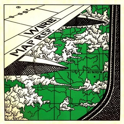
- For my last entry of News & Notes in this format I want to feature one of my favorite bands, WIRE. They were the greatest punk band to come out of the UK (don't argue with me) and their first three albums are a must for any rock fan. On their 3rd record, 154, appeared the song,
Map Ref 41°N 93°W. This is a catchy tune with one of my favorite choruses:
Interrupting my train of thought
Lines of longitude and latitude
Define and refine my altitude
If you're wondering, these coordinates are in southeastern Iowa near Centerville. There isn't much going on there. One of the band members, Graham Lewis, on the meaning of the song: "'Map Ref 41°N 93°W' - There's actually a place called something like Centretown, Iowa. The song is about travelling. I flew from L.A. to New York in 1978 and crossed the mid-west, and it went on and on and on and on. It was just incredible that this grid system was imposed on an enormous stretch of land. The other verse refers to travelling through Holland, by road, seeing all the dykes which is another grid system. 'Curtains undrawn' -- seeing these blocks of flats, like dolls houses with people sitting in them all day with curtains undrawan. It's a travelogue." (Wire...Everybody Loves A History) Here's even more background on the song via geographer John Krygier's blog, Making Maps: DIY Cartography.

|
