
Building a Distributed Shared Print Archive of Western Canadian Topographic Maps (WAML Conference Presentation 2021)
By COPPUL SPAN Phase 6 Working Group: Rhys Stevens (University of Lethbridge), Grace O’Hanlon (University of Manitoba), Daniel Brendle-Moczuk, (University of Victoria), Doug Brigham (COPPUL), Trish Chatterley (University of Alberta), Matt Kaufhold (COPPUL), Larry Laliberté (University of Alberta), Peter Peller (University of Calgary) & Evan Thornberry (University of British Columbia).
“While digital remediation of historic maps expands access, high-resolution images on screen cannot replicate the tangibility of the original – such as the tactile engagement with a large, unwieldy, paper map sheet! Moreover, there is some risk that wholesale digitization can threaten the preservation and continued public access to original artifacts. Physical map collections are vulnerable to disposal because they are viewed as a niche resource by some library managers and require specialized storage space.” – Martin Dodge (2017)
ABSTRACT: A working group of map librarians from across Western Canada formed in February 2021 from amongst members of the Council of Prairie and Pacific University Libraries (COPPUL). This group’s task was to develop processes and procedures for the identification and preservation of print versions of topographic maps of Western Canadian provinces and northern territories published by Canadian federal government agencies. These maps, once identified and inventoried, are to be included within a distributed shared print archive. Inclusion in the archive will ensure that individual print maps remain accessible, opportunities are available for the reallocation of library space, and that maps are preserved for members in a cost-effective way. On October 28, 2021, the COPPUL SPAN Phase 6 Working Group presented an overview of the project and its progress to date at the WAML 2021 Virtual Conference.
Distributed Shared Print Archive Networks
University libraries in many regions are working together to collectively manage collections of print monographs, periodicals and government documents. It is recognized that digital versions of these materials have diminished the role of print but the need for its retention and preservation remains. In the case of paper maps, and topographic maps in particular, their broad scale and fine details are especially valuable for enhancing spatial awareness by providing a holistic view of an area.
A distributed shared print archive network (SPAN) allows libraries to work collaboratively to ensure that an optimal number of print copies of at-risk materials are retained at institutions within the network. For example, when multiple copies of a printed map are held across participating libraries, one network member is designated as being an archive holder and is required to retain it for an agreed-upon duration. Other members of the network are then free to withdraw the archived print map from their own collections with the assurance that a partner library will retain it and make it available if needed.
COPPUL SPAN Phase 6 Initiative – “Topographic Maps”
In Western Canada, the COPPUL Shared Print Archive Network (SPAN) was formed in 2012 when COPPUL libraries in Manitoba, Saskatchewan, Alberta and British Columbia agreed to preserve print materials. Early phases successfully created shared archives for journals, monographs and historical Statistics Canada publications. COPPUL members identified Western Canadian print maps as being a unique type of physical material that would benefit from shared preservation. At the time, it was noted that, while many libraries held topographic series maps, there was no known shared print archive in North America or worldwide that included retention commitments for these types of materials.
Planning for Phase 6 began in 2020 when COPPUL requested the establishment of a working group to oversee it (something not done for previous SPAN phases) as topographic maps were considered a unique format requiring specialized knowledge to plan for their preservation. Members of the working group were recruited by soliciting volunteers from COPPUL’s member organizations. The final group membership consisted of members from six different institutions working in three of the four Pacific and Prairie Provinces, and representing large, medium, and small institutions within COPPUL’s membership. In addition, the working group included COPPUL’s SPAN coordinator and two other COPPUL employees for administrative support and oversight.
Phase 6 formally began in February 2021 with the appointment of team members. The group’s primary task was to develop processes and procedures to identify and preserve print versions of Western Canadian topographic maps published by Canadian federal government agencies. These processes and procedures were to be developed in a way that ensured individual print maps remained accessible, opportunities became available for the reallocation of library space, and that maps were preserved for members in a cost-effective way.
Maps Identified for Inclusion: Canada’s 1:25,000 and 1:63,360 NTS Series Topographic Maps
One of the earliest decisions made by the working group was to select the topographic maps series for inclusion in the shared print archive. In Canada, as in many other nations, the national government has been the entity principally responsible for the production of topographic maps. These maps form Canada’s National Topographic System (NTS) “grid” which was first established in 1904 and formalized in about 1927. The earliest NTS maps produced were not originally series maps but, over time, several different series emerged as Canada’s government sought to systematically map its territory. Two of the earlier series, both now discontinued, were the 1:25,000 series and 1:63,360 series. Both were identified by members of the team as being excellent candidates to archive as part of the COPPUL SPAN project.
Canada’s 1:25,000 NTS maps were produced from the 1930s to 1978 and had originally been created for military use (Nicholson & Sebert, 1981, p. 109). These maps were known as military town plans and, after, 1969, military city maps. Civilian versions of the military city maps were produced for Canada’s largest cities and built-up areas (see Figures 1 & 2). In addition to their historical significance, another reason for the selection of the 1:25,000 series was that it was of a manageable size at 471 sheets in scope for Western Canada, including provinces and northern territories. Multiple editions exist for many sheets (See Figures 3-5). Inventory information for the 1:25,000 map sheets was obtained from Natural Resources Canada, COPPUL, and the University of British Columbia (UBC).

Source: Nicholson & Sebert (1981).

Source: Courtesy Evan Thornberry, UBC


The 1:63,360 (“one-inch”) series and its successor, the 1:50,000, are widely considered the most important series in Canadian mapping (Nicholson & Sebert, 1981, p. 35). Between them, they were the largest scale at which large areas of the country were first mapped (See Figure 6). Maps in the 1:63,360 series were published from the 1920s to the 1950s and are often the oldest topographic maps available for locations in Canada’s western provinces. They are also amongst the most requested and heavily used NTS sheets in COPPUL map collections as they are particularly useful for displaying changes to Canada’s land surface over time (See Figure 7). A total of 419 sheets from the 1:63,360 series are in the project scope according to inventory information obtained from Library and Archives Canada (LAC).
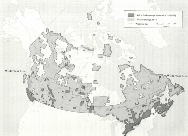
Source: Nicholson & Sebert (1981).

Procedures Used to Create a Shared Print Archive Network of Topographic Maps
Members of the COPPUL SPAN Phase 6 working group met regularly throughout 2021 to develop an outline for the initiative. In addition to identifying appropriate maps series to include, members of the working group developed procedures for (1) the physical validation and inventorying of maps, (2) the creation of new or enhanced existing catalogue records as required to support the retention commitment data, and (3) the registration of retained materials in the OCLC database.
- Physical Validation and Inventorying of Maps
Inventorying of the physical maps to be included in the distributed archive first involved developing and testing procedures for use by participating COPPUL libraries. Individual Google Sheets spreadsheets were created for each participating library to use while inventorying their map cabinets. These spreadsheets enabled libraries to compare their own map holdings against the complete inventory of 1:25,000 and 1:63,360 NTS series maps sheets. A second purpose was to validate a COPPUL library’s existing bibliographic records against the actual maps held in their collections based on verified inventory metadata (e.g., title, creator, edition, scale, year published, notes, etc.).
During the completion of the inventory, physical condition of the maps sheets was also checked and documented to identify any major faults that obscured content. The working group felt that understanding the physical state of maps in each collection would be valuable for ensuring that only the highest quality maps were retained when multiple copies of the same sheet were available. It would also simplify the identification of the best candidates for potential future digitization initiatives. - Creation of New or Enhancing Existing Catalogue Records for Maps
While establishing preliminary contact with member libraries interested in participating in the project, the group found that many local library catalogues did not have sheet-level data (i.e., MARC records) describing their topographical maps. Instead, libraries typically had either series-level catalogue descriptions or external spreadsheet listings of map holdings. Maps in some libraries were entirely uncatalogued. Common procedures were established for participating libraries to use when creating new catalogue records for their maps or enhancing existing ones. These new or modified records for individual map sheets were also necessary so they could be used to document retention commitment data. Library and Archives Canada (LAC) catalogue records for both the 1:25,000 and 1:63,360 NTS series maps were obtained for participating libraries to use for these purposes. - Registration of Retained Map Materials in the OCLC Database
Similarly to previous SPAN Phases, the ability to track retention commitments of participating institutions depended on the map sheets being individually catalogued and the MARC records containing a field denoting the retention commitments (Table 1 provides an overview of specific archive holder commitments). After the participating institutions have confirmed the map sheets they commit to retain, they are responsible for adding a retention commitment notation into the MARC records of each catalogue record of retained map sheets. Updated map catalogue records are to be uploaded to OCLC.
The working group recognized that the findability of individual maps included in the shared print archive would be enhanced by registering retention commitments with the OCLC shared print services database. Registration with OCLC helps to ensure that individual sheets in map collections are both secure and easily identifiable. Once registered, commitments are discoverable in products such as Connexion, WorldShare Record Manager, WorldShare Collection Manager, FirstSearch, and the WorldCat Metadata API.
| Table 1: COPPUL SPAN Phase 6 Topographic Maps – Archive Holder Commitments · Archive Holders commit to retain map materials for 30 years (until 01 April 2052). · Archive Holders commit to making materials available, through interlibrary loan or on site. · Archive Holders to transfer to non-public storage area when possible. Guidelines for Assigning Retention Commitments · Retain all map sheets held at only one participating institution. · Retain two copies of sheets held at multiple institutions. · Institutions can ask to retain all of their sheets. · Multiple copies of maps mitigate risk of physical damage or loss. |
Progress to Date on Creating a Shared Print Archive Network of Western Canadian Topographic Maps
As of December 2021, the working group had completed its work developing processes and procedures for the creation of the archive itself. These procedures were presented in September 2021 at COPPUL’s Phase 6 “Kick Off” meeting for prospective participating institutions. Individuals responsible for maps at participating libraries are currently involved in completing their inventory work and submitting their responses back to the SPAN coordinator. In early 2022, COPPUL will contact the eleven participating libraries to discuss the details of MARC records and the OCLC Shared Print Registry. Shortly thereafter, COPPUL will send information about OCLC MARC records to participants and confirm which sheets Archive Holders will be asked to commit to retain. Participants will then begin updating their local bibliographic records and start transferring materials to secure, non-public storage if possible. At that time, Archive Holders (or COPPUL on their behalf) will begin reporting their commitments to the OCLC Shared Print Registry.
We anticipate that the libraries and COPPUL will have largely completed their work by June 2022 and that the distributed shared print archive will be “populated.” Once completed, the SPAN Phase 6 project will have achieved its objective of having its member libraries jointly create a distributed shared archive of print topographic maps of Western Canada. This will serve to ensure their physical preservation and availability for future generations of students and researchers.
Due to the initial success of the COPPUL SPAN Phase 6 project to create a distributed shared print archive of 1:25,000 and 1:63,360 NTS series maps, the working group has now begun to identify additional print topographic map series routinely held by academic libraries in Western Canada for future phases. For complete information about this initiative, see the COPPUL SPAN Phase 6 Working Group web page.
References
Dodge, M. (2017). Cartography I: Mapping deeply, mapping the past. Progress in
Human Geography, 41(1), 89-98. https://doi.org/10.1177/0309132516656431
Nicholson, N. L., & Sebert, L. M. (1981). The maps of Canada: A guide to official
Canadian maps, charts, atlases and gazetteers. Wm Dawson & Sons, Ltd.
You must be logged in to post a comment.